
For as many luxuries as GPS provides, one is not the ability to toss out the traditional map and compass. Getting lost is inconvenient at best and terminal at worst. So do not stake your life on your GPS alone. It is used optimally in conjunction with other navigation tools such as: maps, compass, altimeters, pedometers, watches and notebooks.
It is important to learn these other tools because GPS receivers are electronic, and like any other form of electronics, they are prone to failure or dead batteries.
Map Basics
Maps come in a number of different scales, but when its time to get serious, the greater the detail the better. The state road map kept in the glovebox might be a 1:500,000 scale. Used as a highway reference where the entire state fits on one side. The scale rating on this map is one inch equals 500,000 inches on the ground (approximately 8 miles). The most detailed standard map used in the backcountry is the 7.5 Minute Topo. These highly detailed maps are produced by the U.S. Geological Survey (USGS), and have a scale of 1:24,000, where 2 5/8 inches equals one mile. They are 6.5 miles wide, 8.5 miles long, and cover approximately 55 square miles. Topo stands for topographical which provides a 3-D prospective of the ground. This is done with contour lines that indicate elevation.
Map Scales
1:500,000 1 inch = 8 miles
1:250,000 1 inch = 4 miles
1:150,000 1 inch = 2.4 miles
1:62,000 (15 minute) 1 inch = 1 mile
1:24,000 (7.5 minute) 1 inch = 20,000 feet
Seven and a half minute maps are not practical for cross-country travel, but ideal for when detail is required to travel into more remote wilderness areas. United States 7.5 Minute maps are made and updated by the U.S. Geological Survey. They can be purchased for about $4.00 at outdoor stores or from the Government over the phone.
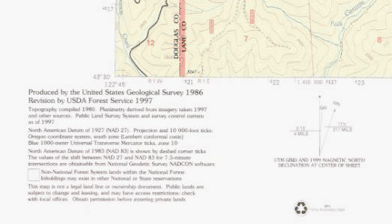
For our trip to the Bohemia mining district we purchased at 7.5 Minute Topo map titled Fairview Peak Quadrangle-Oregon. The bottom section of the map gives its details which includes the following:
Map Date: Produced in 1986, and updated in 1997. Topo info from 1980.
Datum: North American Datum of 1927 (NAD 27). This is important because out GPS receiver will have to be set to this datum if not defaulted to in anyway. This is done on most receivers by selecting the datum options under a set up menu.
Declination Diagram: The scale indicating the degree a compass is adjusted to correct magnetic north to true north. This maps declination is 17.5 degrees.
Map Scale: 1:24,000, one inch equals 24,000 inches on the ground.
Mileage scale: One mile equals about 2-5/8 inches.
Contour Interval: The elevation lines are 40’ apart, every 5th darker brown line indicates the elevation in feet.
Misc. Information: Where this map is in relationship to the state, map names surrounding this map, and list of symbols for highways and roads.
Another advantage of 7.5 Minute maps is that they include the two main types of coordinates. Most maps are formatted with Latitude/Longitude. These maps also include Universal Transverse Mercator (UTM) coordinates.
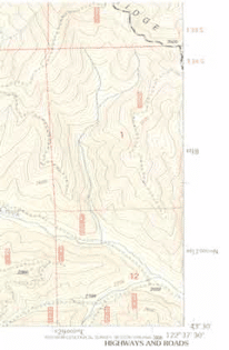
| Map Coordinates (Includes Lat/Long and UTM) 4818 UTM Northing 4817000mN Full UTM Northing 529000mE Full UTM Easting (lower left) 43° 30’ 43 Degrees Latitude 122° 37’ 30” 122 DegreesLongitude (lower right) |
There are a number of map coordinates but the primary two are Latitude/ longitude and Universal Transverse Mercator (UTM). Most North American GPS units are programmed to default to Latitude/Longitude. UTM coordinates can be selected by the set up menu. Either system provides a numeric set of coordinates in either degrees or meters, for any location in the world. Here are the basics on each system.
Latitude/Longitude
Latitude lines run horizontally around the globe and parallel the earth’s equator, being the staring point at zero degrees. The equator also splits the globe in north and south hemispheres. Lines run horizontally to 90 degrees at the north and south poles. They measure north-south coordinates.
Longitude lines circle the globe vertically intersecting the north and south poles to measure east-west coordinates. The starting point is zero degrees at Greenwich, England, and wrap around the earth east and west to 180 degrees.
Each degree equals 69.05 miles. For greater detail, degrees are split into minutes and seconds. One degree equals 60 minutes, each minute equals 60 seconds.
1° = 60’ (minutes), 1’(minute) = 60” (seconds).
That is how Latitude/Longitude coordinates are written:
Degrees° Minutes’ Seconds”
122° 37’ 30” or with a decimal point 122° 37.50’ or 122.6250°
(All three are the same location.)
One degree = 69.05 statute (ground) miles
One minute = 1 nautical mile or 1.15 statute miles
One second = 100 feet
This applies to Longitude distances only at the equator. The length in the Longitude lines between the Meridians (vertical Latitude lines), decrease as they approach the north and south poles.
Here are the coordinates for Sunriver, Oregon:
N 43° 52’ 35”, W 121° 27’ 10”
or
N 43° 52.589’, W 121° 27.170’
Latitude is listed first, measuring the north-south position. This address is north of the equator by 43 degrees, 52 minutes and 35 seconds, or (52.589 minutes.) Longitude is listed second, measuring the east-west position. This address is west of Greenwich, England by 121 degrees, 27 minutes and 10 seconds, or (27.170 minutes.)